
Have you ever visited the breathtaking south of Iceland? Did you know that the south is the area where nine out of the ten most beautiful places in Iceland are located? Well, now you know, and that’s why we curated for you the list of the very best things to do in south Iceland!
In this article, we delve into the story of South Iceland, from its mystical glaciers to its picturesque cities, and discover why this part of it attracts adventurers and beauty lovers from all over the world. Come and take a look with us!

The Best things to do in South Iceland in 2024
Thórsmörk: Thor’s valley
Thorsmork, also known as Þórsmörk, is a jewel in the Icelandic landscape that brings all adventure and natural beauty enthusiasts to ecstasy.
Lying between three glaciers – Mýrdalsjökull, Eyjafjallajökull, and Tindfjallajökull – Þórsmörk forms a green, protected paradise that offers many opportunities for hiking and wildlife exploration.
Why go?
Þórsmörk offers several hiking routes that are suitable for a wide range of tourists. Whether you are an experienced hiker or a casual walker, you will find a suitable route.
The Laugavegur Trail, one of Iceland’s most famous hiking routes, starts and ends in Þórsmörk, making it a popular spot for hikers and tourists in general. It’s also an ideal place for photographers and nature lovers!
How to get there?
JEEP TOUR
The area lies in the highlands of Iceland – which means that getting there can be an adventure itself. One of the most popular (and also convenient) ways to reach Þórsmörk is by joining a guided super jeep tour.
These cars are specially modified 4×4 vehicles which are ideal for harsh Icelandic terrain. Tours are offered by various companies, and they depart mainly from Reykjavik.
Tip: We suggest taking this very popular jeep tour where you get to enjoy so many spectacular hiking options and adventurous rides over various unbridged glacial rivers. This is the perfect tour to explore the wonders of the valley while experiencing an adventurous 4×4 Super Jeep drive!
BUS
Some bus companies provide scheduled services to Þórsmörk – but only in summer months. These buses depart from Reykjavik or other major towns and follow specific routes.
However, the availability of bus services may vary, so don’t forget to check schedules and most importantly: book in advance!
CAR
If you prefer more flexibility in your schedule, you can rent a 4×4 vehicle, allowing you to drive there on your own.
It’s important to know that the roads leading to Þórsmörk are rough F-roads that may require a more capable vehicle.
But as you might know, road conditions can change rapidly, so checking the latest information is very important.
Tips on visiting
Explore the area around
Thorsmork is part of the Highlands of Iceland, one of the most stunning areas in Europe.
We recommend devoting more than just one day to exploring the best places in the Icelandic Highlands. There are just too many breathtaking spots in every corner!
Check road and weather conditions
Check the current road conditions before you set off, especially if you plan to drive yourself to the location in a rental car.
Roads can be impassable in certain weather conditions and can change rapidly. Iceland’s weather is notoriously unpredictable, so check the Icelandic weather forecasts frequently so you don’t end up being stuck.
Clothes in layers
The weather and temperatures can vary throughout the day. Dress in layers to adapt to changing conditions. Waterproof and windproof clothing is recommended as the weather can be rough.
And, as we mentioned earlier, you can get stuck and spend there more time than you would like! It’s wise to bring essential supplies with you. Carry enough food, water, and any necessary equipment.

Landmannalaugar: landscape of rainbow
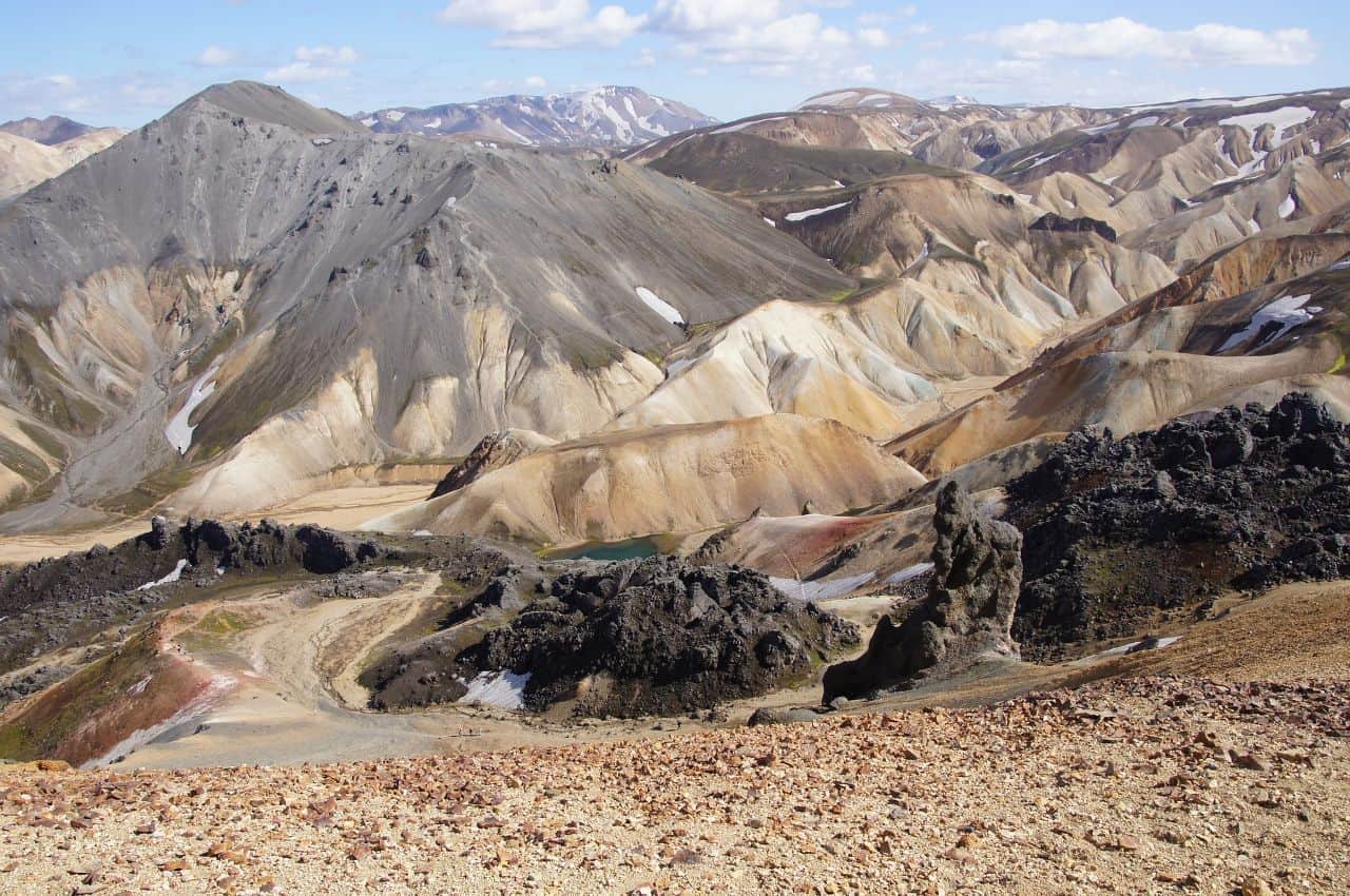
Landmannalaugar (translates to Rainbow Mountains) is one of the most beautiful and popular hiking spots in the whole of Iceland.
The small mountainous area with hills is famous for its colorful soil, which is made of magmatic minerals and creates an incredible play of colors on sunny days.
Why go?
With its colorful colors and geological formations, Landmannalaugar is a paradise for amateur and professional photographers who like a bit of hiking.
The ever-changing light conditions create dynamic and breathtaking scenes, making it the perfect place to capture stunning images.
Landmannalaugar is also home to unique flora and fauna adapted to the high mountain environment. Moss-covered lava fields, alpine plants, and occasional wildlife sightings add to the appeal of this unusual landscape.
How to get there?
The Landmannalaugar area is only accessible between June and September, during the rest of the year the road leading to the campsite and the trail starting point is closed. There is also a possibility of getting there by foot.
It’s also a popular starting or ending point for the Laugavegur Trek, a multi-day hiking trail that connects Landmannalaugar with Þórsmörk. If you’re an avid hiker, you can reach Landmannalaugar by foot as part of the Laugavegur Trek.
Tip: You could take this day tour to the Southern Highland of Fjallabak to visit Iceland’s Landmannalaugar and Hekla Volcano area. You get to hike through Laugahraun, Vondugil Canyon, and Brennisteinsalda, before relaxing in a natural hot spring.
There are many ways on how to get to Landmannalaugar by car:
- From Reykjavik, take the F32 and F208, which is a gravel road. This route can also be driven by a conventional car without much difficulty. The road ends with a ford. The road is about 195 km long.
- From the east, the F208. You have to cross more than 10 fords on the way and therefore it is passable only by 4x4s.
- From the west the gravel dirt road F26 and then the road number F225 leads. This road is only passable by off-road vehicles due to several fords.
Tips on visiting
Daylight hours may be limited. Plan your activities accordingly, and if you are going on a hike, consider starting early to make the most of the daylight. Think about this especially when taking the multi-day trails.
If you like to take photos, bring your camera, spare batteries and memory cards. Landmannalaugar offers incredible opportunities to capture unique and stunning landscapes as well as wildlife and stunning flora.
Don’t forget your swimsuit! Not far from the hut of the same name, a hot and a cold spring flows out from under the lava field and both flow into one lake, which provides tourists with a great bath.
Selfoss: a town which has it all
When feeling lonely during your travels in nature, try to visit Selfoss! It is a town in the southern part of Iceland on the Ölfusá River. Selfoss proudly belongs to Icelandic hidden gems among cute Icelandic villages!
The main road No. 1 Hringvegur passes through it, and it has approximately 6300 permanent residents. Even though it’s size, it has many things to offer!
Why go?
Selfoss is surrounded by typical Icelandic geothermal activity. While there might not be specific hot springs within the town, you can explore nearby geothermal areas like Reykjadalur, which is known for its hot river.
Also don’t forget to visit some local restaurants and pubs and take it as an opportunity to try different cuisines, for example, Plokkfiskur: A fisherman’s stew made with fish (usually cod or haddock), potatoes, onions, and béchamel sauce.
How to get there?
Selfoss is approximately 50 kilometers (about 31 miles) east of Reykjavik, so if you drive east on the Ring Road (Route 1) from Reykjavik, following the signs for Selfoss, you may reach it in under an hour.
There are also scheduled bus services connecting Selfoss to Reykjavik and other towns in Iceland. Bus companies like Strætó operate routes that pass through it.
Tips on visiting
Horseback Riding:
Consider going horseback riding! Iceland is known for its unique Icelandic horses, and there are opportunities for horseback riding tours in the surrounding countryside, which is perfect for (not only) horse lovers.
Local Events and Festivals:
Check for local events and festivals. Selfoss, like any other bigger town, hosts various cultural events throughout the year, providing an opportunity to experience Icelandic traditions, so you can feel like a local for a while.
Golf Courses:
If you enjoy golf, the Selfoss Golf Course provides a scenic setting for a round of golf with views of the surrounding countryside. Only a handful of people can say that they played golf while visiting Iceland!

Geysir Geothermal area: the one which gave name to all
Look at the geyser that gave the name to all other geysers, i.e. hot springs gushing from the Earth’s interior!
Today, Geysir is mostly dormant. But Stokkur and others which are also in the Geysir Geothermal Area, in the valley known as Haukadalur Valley, are quite active – so that means worth visiting!
Why go?
The area is famous for its geysers, especially the Great Geyser, which is one of the oldest known geysers in the world – even though it has been inactive since 2016.
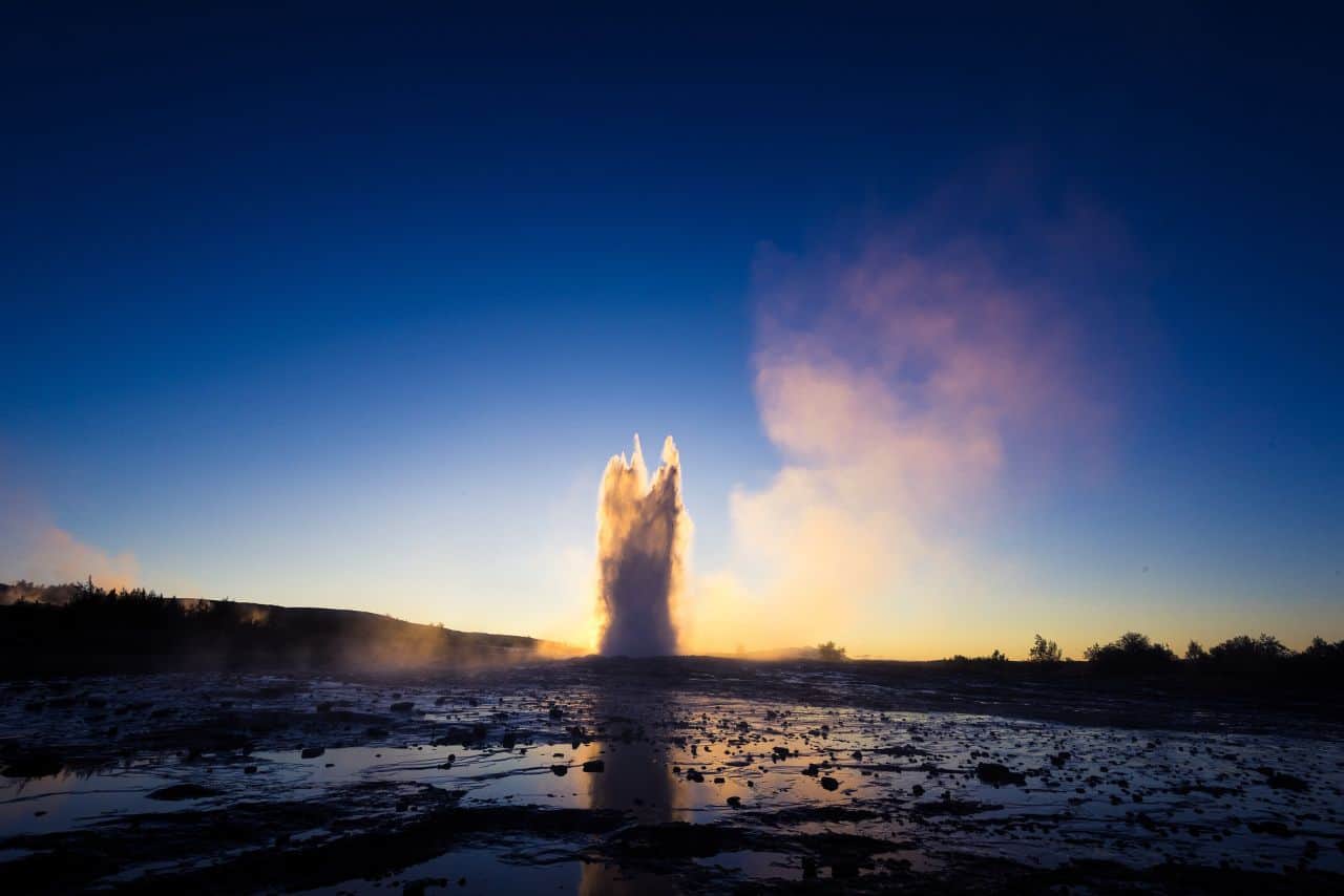
But don’t worry! The Strokkur Geyser, located nearby, is erupting every 5 to 10 minutes and shooting hot water high into the air.
Witnessing this natural phenomenon can be a unique and breathtaking experience. The predictability of its eruptions allows tourists to prepare and capture the impressive moments on camera.
Visitors can explore these unique features and sometimes even dip their feet in the warm water.
How to get there?
Geysir Geothermal Area is located in southwestern Iceland, and it’s part of the Golden Circle, a popular tourist route that includes several key attractions. Geysir is approximately 100 kilometers (about 62 miles) east of Reykjavik, the capital of Iceland.
The most common way to get here is by car. You can rent a car in Reykjavik and drive along Route 1 (also known as the Ring Road) heading east.
But again, there are tons of tour companies which offer guided tours which can be enriched by the offer to visit more places at once.
Last but not least, although public transport options in the area are limited, there are several bus routes between Reykjavík and destinations on the Golden Circle.
However, public transport may not provide sufficient flexibility to explore the area at your own pace.
Tips on visiting
Visit Early or Late
Geysir is a popular tourist destination, so consider visiting early in the morning or later in the day to avoid the crowds. This can provide a more peaceful experience and even better photo opportunities.
Eruptions
If you’re interested in capturing the eruptions of the Strokkur geyser, be patient. It erupts approximately every 5-10 minutes, so position yourself in a good vantage point and be ready with your camera.
Be mindful of the steam and mist that can affect your camera equipment. Wiping your lens regularly may be necessary.
Go Visit Other Hot Springs
The temperature in geysers lies between 80-100 degrees Celsius, but it can reach 240 degrees Celsius below the surface. So, please, don’t bathe in here!
But, you can bathe in many other amazing and wild hot pots around! The Iceland hot spring map should help you find all of them.
Skógafoss: King of waterfalls
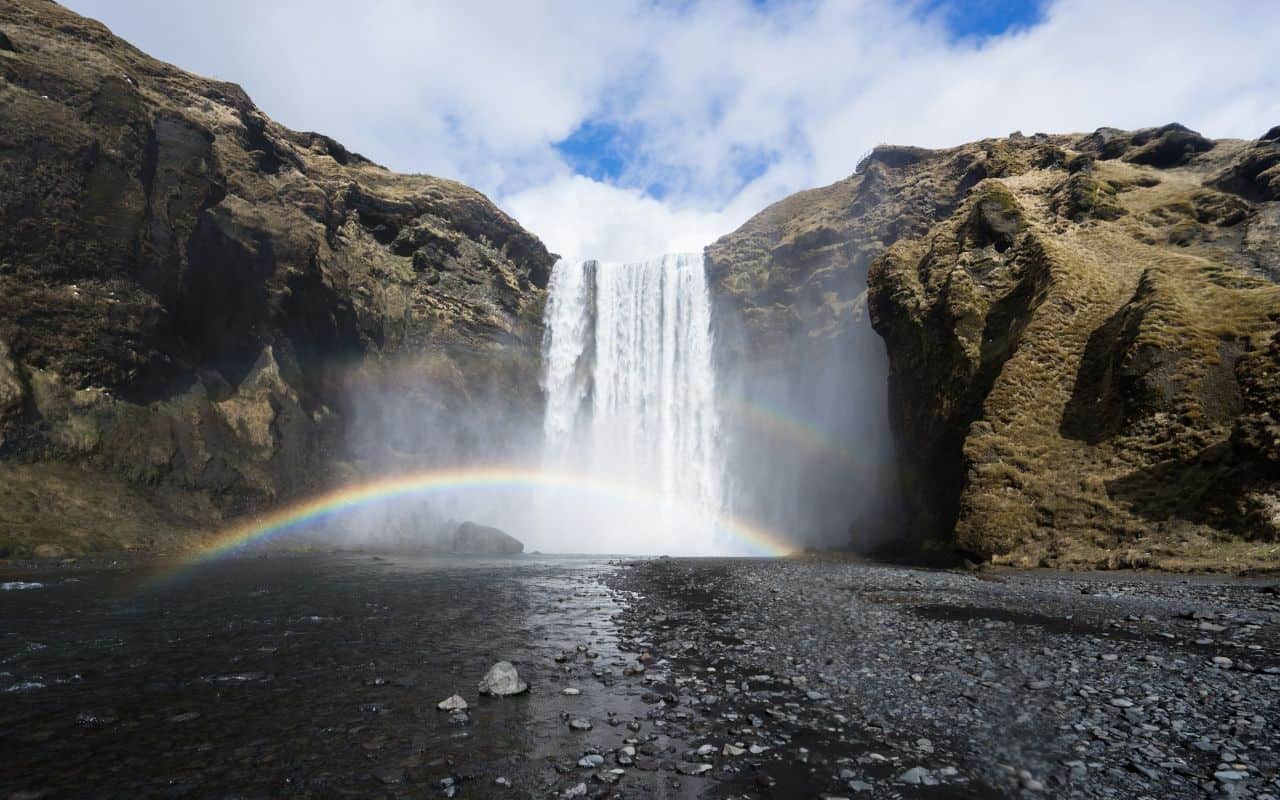
Skógafoss waterfall on the Skóga River is located in the south of Iceland near the town of Skógar. It falls from the former coastal cliffs, which are now about 5 kilometers away from the sea.
The waterfall is impressive in size, standing at a height of approximately 60 meters (197 feet) and having a width of about 25 meters (82 feet).
Due to the constant spray produced by the waterfall, on sunny days, it’s common to see vibrant rainbows forming in the mist. This adds to the picturesque and magical atmosphere.
Why go?
Skógafoss is definitely one of the most famous and special waterfalls worldwide. A staircase along Skógafoss takes visitors to an elevated platform with panoramic views of the surrounding area, which adds an element of exploration to the visit. It’s special for locals too!
According to one legend, the Viking settler Þrasi Þórólfsson buried a treasure chest behind Skógafoss. Legend has it that the locals found the chest years later, but only managed to pick up the ring on the side of the chest before it disappeared again.
We also recommend visiting the Skógar Museum, which provides insight into Iceland’s cultural heritage, displaying various artifacts and historical buildings.
How to get there?
Skógafoss is easily accessible by car and is a popular stop for tourists exploring the southern region of Iceland. It’s approximately 150 kilometers (93 miles) from Reykjavik, making it an ideal day trip from the capital.
Take the Ring Road (Route 1) eastward from Reykjavik, passing through scenic landscapes and small towns.
As you approach Skógar, you’ll see signs for Skógafoss. The waterfall is visible from the road. If you are coming from the southeast (e.g., Vik), take the Ring Road (Route 1) westward.
As always, there are also many bus tours available, which can be more comfortable – but it doesn’t provide as much free time to explore the area on your own.
Tips on visiting
Rain Gear
Consider bringing a waterproof jacket and pants, or at least a rain poncho or an umbrella, to stay dry from the mist generated by the waterfall. It also helps from getting cold quickly.
Climbing the Stairs
Take the opportunity to climb the stairs to the top of this magnificent waterfall. The viewpoint provides a panoramic view of Skógafoss and the surrounding landscape.
Safety
Respect safety barriers and guidelines. Skógafoss is a powerful waterfall, and it’s important to prioritize your safety.
If visiting in winter, be prepared for icy conditions. The mist from the waterfall can freeze, creating icy surfaces.
Jökulsárlón: Glacier lagoon
Jökulsárlón is situated near the edge of Vatnajökull National Park, approximately 380 kilometers (about 236 miles) east of Reykjavik.
It’s renowned for its floating icebergs which break off from the glacier, gradually making their way to the lagoon. The icebergs come in various shapes and sizes, creating a dynamic and frequently changing landscape.
Why go?
Jökulsárlón is a heaven for birdwatchers. Seals are also commonly spotted in the lagoon, often resting on the icebergs or swimming in the waters of the lagoon.
In winter, Jökulsárlón becomes an excellent location for viewing the Northern Lights (Aurora Borealis), especially during clear nights.
Visiting Jökulsárlón offers an unforgettable experience, allowing you to witness the powerful forces of nature and the beauty of Iceland’s glacial landscapes.
How to get there?
The lagoon is easily accessible from the Ring Road (Route 1), making it a popular stop for tourists exploring the South Coast or completing the Ring Road by both car or bus.
Visitors can take boat tours on the lagoon to get up close to the icebergs. These tours offer a unique perspective of the glacial lake.
Tips on visiting
Boat Tours
Consider taking a boat tour on the lagoon to get up close to the floating icebergs. These types of tours are often available during the summer months.
There is also a huge chance of seeing seals and other Icelandic animals! Binoculars may be handy there.
Diamond Beach Visit:
Don’t miss Diamond Beach, the nearby black sand beach where icebergs from the lagoon wash ashore.
The contrast between the ice and the dark sand is visually striking not only for photographers.
Visitor Centre:
Visit the Jökulsárlón Visitor Centre for information about the lagoon, nearby attractions, and the Vatnajökull National Park. The center may also provide updates on ice conditions and wildlife sightings.